Agricultura de precisão
APLICAÇÃO DE PRODUTOS DE SENSORIAMENTO REMOTO ASSOCIADOS AO NDVI
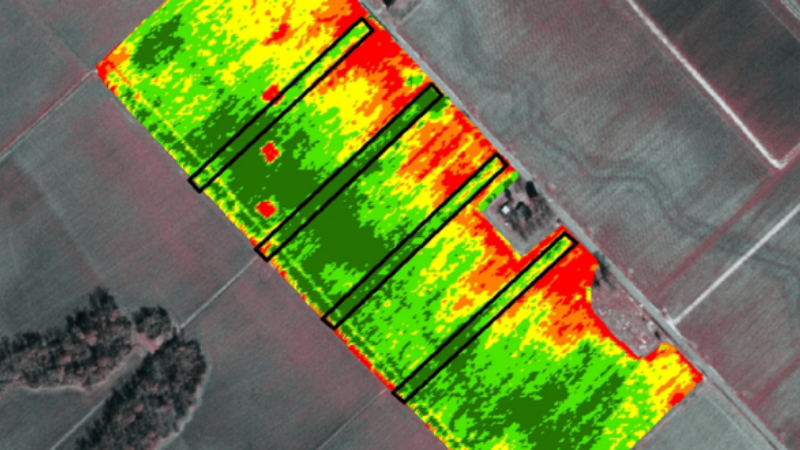
Uma metodologia bastante utilizada na elaboração de mapas de uso e ocupação do solo é a classificação digital de imagens de sensoriamento remoto. O Índice
Uma metodologia bastante utilizada na elaboração de mapas de uso e ocupação do solo é a classificação digital de imagens de sensoriamento remoto. O Índice
Cadastre-se para receber nossa newsletter e se mantenha atualizado no mundo do #AGRO
Faça parte da revolução que a agricultura precisa
| Cookie | Duração | Descrição |
|---|---|---|
| cookielawinfo-checkbox-analytics | 11 months | This cookie is set by GDPR Cookie Consent plugin. The cookie is used to store the user consent for the cookies in the category "Analytics". |
| cookielawinfo-checkbox-functional | 11 months | The cookie is set by GDPR cookie consent to record the user consent for the cookies in the category "Functional". |
| cookielawinfo-checkbox-necessary | 11 months | This cookie is set by GDPR Cookie Consent plugin. The cookies is used to store the user consent for the cookies in the category "Necessary". |
| cookielawinfo-checkbox-others | 11 months | This cookie is set by GDPR Cookie Consent plugin. The cookie is used to store the user consent for the cookies in the category "Other. |
| cookielawinfo-checkbox-performance | 11 months | This cookie is set by GDPR Cookie Consent plugin. The cookie is used to store the user consent for the cookies in the category "Performance". |
| viewed_cookie_policy | 11 months | The cookie is set by the GDPR Cookie Consent plugin and is used to store whether or not user has consented to the use of cookies. It does not store any personal data. |